|
| |
 Boreham Street in East Sussex is part of the parish of Wartling , and therefore shares
much of its history. The village is about 2 miles north of Wartling
Hill, the other part of the parish where the church is located. Boreham Street in East Sussex is part of the parish of Wartling , and therefore shares
much of its history. The village is about 2 miles north of Wartling
Hill, the other part of the parish where the church is located.
In the Domesday survey, it had a population of 280, land able
to support 18 ploughs, woodland for 200 pigs three salt
workings, and a chapel.
The chapel was mentioned as being given to the College of Hastings
by the Count of Eu . The current church dates from the 13th century,
and is believed to lie on the land where the chapel used to be.
During the late 1500's there were a large number of French
names recorded in the church register, it is probable that
they had been employed at Ashburnham and other local Furnaces
to help set up the process.
In the church are two very rare iron tombstone heads, which
were provided by Jonathan Harmer of Heathfield .
During the second world war many defense pill boxes were built
in the area, to protect from invasion through the Pevensey
Marshes . To the East of the church is a command post built to
cover the Marshes and the Ashbourne valley. |
|
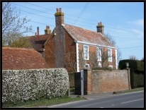
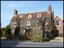 Boreham Street in East Sussex is a very pretty village built on the main
Ninfield to Hailsham road, and its high street has many
beautiful buildings. Boreham Street in East Sussex is a very pretty village built on the main
Ninfield to Hailsham road, and its high street has many
beautiful buildings.
It is on the top of the ridge, and has many wide vistas
to the north across the Ashbourne valley, and during the
17th century, it would have been possible to see the
smoke from Ashburnham Furnace, and the cannons being
shipped downstream. |
|
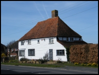 Boreham Street in East Sussex has a number of restaurants, and a garage,
and between itself and Windmill Hill is a modern tennis
training centre. Boreham Street in East Sussex has a number of restaurants, and a garage,
and between itself and Windmill Hill is a modern tennis
training centre.
Wartling Hill is very small, and only has the Church a
public house and post box for services.
The nearest train service is from Pevensey to the south west
which is on the Hastings to Eastbourne line. |
|
| Boreham Street is shown as the red symbol on the map. |
|
|
Nearby Villages
(click on symbol to see the village page) |
| Village= | |
Town= | |
Recorded in Domesday= |  |
| |
|
|
Ashburnham |
(Last Iron Furnace in Sussex) | | 2.49 miles |
|
|
Battle |
(William the Conqueror prevails) | | 5.83 miles |
|
|
Bodle Street |
(White Horse on the roof) | | 2.78 miles |
|
|
Catsfield |
(Iron, Railways and Clocks) | | 3.96 miles |
|
|
Crowhurst |
(Village devastated by the Normans) | | 5.81 miles |
|
|
Hailsham |
(Ropes and Napoleon) | | 4.98 miles |
|
|
Hellingly |
(Only remaining Ciric in Sussex) | | 5.33 miles |
|
|
Herstmonceux |
(Castle and Observatory) | | 2.14 miles |
|
|
Hooe |
(The Haunt of Smugglers) | | 1.72 miles |
|
|
Horam |
(Which Station do we get off at ?) | | 6.70 miles |
|
|
Ninfield |
(Last of the Iron Stocks) | | 2.64 miles |
|
|
Normans Bay |
(Last Invasion in 1066) | | 3.74 miles |
|
|
Penhurst |
(Beautiful yet Remote) | | 3.66 miles |
|
|
Pevensey |
(Ancient Roman Fortification) | | 4.08 miles |
|
|
Polegate |
(Fine old Tower Mill) | | 6.55 miles |
|
|
Wartling |
(World War II defence centre) | | 1.30 miles |
|
|
Windmill Hill |
(Largest Post Mill in Sussex) | | 1.26 miles |
|
|


